Minutes, Notices and Maps: Choosing a Local Record to Explore
Choose local records by the questions you want to ask: minutes, notices and maps reveal different civic decisions without pretending to tell the whole story.
Minutes, notices and maps answer different questions about a place, so the best local record to explore depends on what you are curious about. Minutes can trace a decision through public discussion; notices show what people were asked to know or do; maps make changing boundaries and practical arrangements visible. Each is a partial view, not a complete account.
Start with a question, not a favorite document
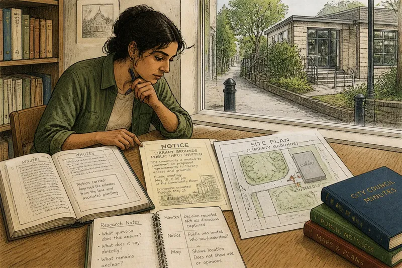
Imagine a clearly hypothetical situation: a curious resident named Maya wants to understand why a small lane beside a neighborhood library has a marked entrance and a patch of public planting. She has heard neighbors call it “the cut-through,” but does not know who arranged it or what it was meant to serve. Rather than hunt for a single definitive record, she frames a few separate questions: Was there a public decision? How was the change announced? What did the site look like on paper?
That distinction gives her a useful route through a local archive. A pair of meeting minutes may illuminate deliberation, a notice may reveal the public-facing message, and a map may show the lane in relation to nearby streets or properties. The records can inform one another without being forced to agree or made to speak for people they never recorded.
Minutes reveal decisions and their limits
Maya begins with minutes from a local public body, perhaps a city council committee, parks board, or library board. Minutes are useful when the question concerns what an organization considered, approved, deferred, or referred elsewhere. They can also point toward a meeting date, agenda item, department, or named project that helps narrow later searching.
She looks for the lane, the library, planting, access, or a related street name, while keeping in mind that records may use formal language rather than neighborhood terms. A heading such as “site access” might be relevant even if the minutes never call the path a cut-through. If the search turns up nothing, that does not establish that no decision occurred; the matter might sit in another board’s records, appear under a different label, or fall outside the minutes she has.
Minutes also compress conversation. They may preserve a motion and its outcome but omit the reasons residents gave, disagreement that did not become a formal action, or informal work that happened later. Maya can treat them as evidence of recorded institutional action, not as a transcript of everyone’s experience.
Notices show what the public was told
Next, Maya looks for notices: posted announcements, mailed circulars, public meeting notices, or short updates distributed by a local office. These records are suited to questions about communication. What did officials tell residents? When were they asked to attend, comment, avoid an area, or use a different entrance? Which details were made prominent?
A notice can preserve a practical detail absent from minutes, such as a temporary closure or a request for public comments. Its audience and purpose matter, though. A notice may be written for nearby property owners, library patrons, contractors, or meeting attendees, rather than for every person who used the lane. It can show what its issuer intended to communicate, but not who saw it, understood it, or agreed with it.
Maya compares the notice’s wording with the meeting record. If a notice invites comments before a board meeting, the minutes might later record a decision, but the two documents do different jobs. The notice helps her understand the public invitation; the minutes help her understand the body’s recorded action. Neither automatically captures the full response from neighbors.
Maps make location and change easier to see
For the spatial question, Maya turns to maps. A city street map, library site plan, zoning map, or public works drawing may show a lane’s alignment, access points, nearby parcels, or the relationship between the path and the library. Maps are particularly helpful when written records use a location description that is hard to picture.
She checks the map’s title, date or edition information, legend, and stated purpose before drawing conclusions. A planning map may emphasize land use; a street map may prioritize routes; a site plan may focus on entrances and structures. A line or symbol can represent a proposed feature, a legal boundary, or a physical feature, depending on the map. Like a labeled drawer, a map sorts information according to its maker’s purpose; it does not hold every detail about what happened there.
Comparing maps from different periods can suggest that a route or boundary changed, but the comparison needs care. The maps may use different scales, conventions, or definitions. Maya notes what each map actually marks and avoids treating an apparent difference as proof of when or why a change occurred.
Match each record to the question it can answer
Once Maya has gathered a small set of documents, she keeps a simple note beside each one: what question it helps with, what it says directly, and what remains unclear. This prevents a common archival leap: using a record that mentions a place as if it answered every question about that place.
- Choose minutes to trace a public body’s recorded discussion, motion, referral, or decision.
- Choose notices to examine what information was circulated and what action or response was requested.
- Choose maps to locate features, boundaries, routes, or planned arrangements in space.
- Compare records when you need to connect a decision, its announcement, and its mapped setting.
- Keep a gap visible when a record is silent about lived use, informal work, or residents’ views.
Say Maya finds hypothetical minutes recording approval of a path entrance, a hypothetical notice inviting comments on the library grounds, and a hypothetical site map marking the entrance beside the lane. Together, these would let her describe a recorded decision, a public communication, and a mapped location. They would not establish who used the lane most, how neighbors felt about the planting, or whether the announced plan unfolded exactly as drawn.
Which local record should you look for first?
What can meeting minutes tell me about a neighborhood place?
Minutes can show what a public body formally recorded, including motions, referrals, and decisions related to a site. They may not preserve every argument, informal conversation, or resident’s perspective.
Can a public notice prove that residents knew about a decision?
A notice can show what an issuing office said it circulated and how it framed an invitation or change. On its own, it cannot show who received or read it, or what people thought about it.
What should I check before interpreting an old map?
Check its stated purpose, legend, scale, labels, and any edition or date information. Those details help distinguish what the map represents from what a reader might assume it represents.
What if the three records appear to disagree?
First check whether they refer to the same location, stage of a project, and kind of information. A notice may describe a proposal while minutes record a later decision, and a map may show a plan rather than a completed feature.
Keep the result specific and open
Maya’s careful account can say that certain records connect a board action, a public announcement, and a mapped entrance. She can also say which parts remain unanswered, such as how the lane entered everyday use or how different neighbors valued it. That is not a failure to finish the story; it is an honest boundary around what these documents support.
For your own local record search, choose the document that fits the question you can state most clearly, then let the next question emerge from what the record actually contains. Minutes, notices, and maps are strongest as distinct kinds of evidence, read side by side when useful. The most reliable account leaves room for people, routines, and experiences that the paperwork was never designed to capture.